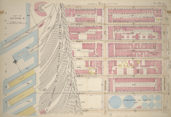
Map from 1899 depicting West 65th to 71st street. From The Lionel Pincus & Princess Firyal Map Division, The New York Public Library.
If you like looking at old maps (and who doesn’t?) you will want to check out a trove of 20,000 old maps recently released in digitized form by the New York Public Library. As part of the release, the NYPL also created an amazing tool that lets anyone overlay old maps on top of current ones.
The map above shows the area from West 65th street to West 71st from Amsterdam Avenue to the river as it looked in 1899. The East side of that map is where Lincoln Center is today — at the time it was a very dense urban neighborhood. To the West you can see the old railyards, which are now the site of Riverside Boulevard, the Trump-Extell towers and Riverside Park South. Where once there were four piers jutting into the Hudson River, there is now only one.
Using the NYPL “warping” technology, someone took that old map and superimposed it onto the same coordinates of a current-day map, allowing users to drag a bar at the bottom that gradually makes the old map transparent. Go ahead and look at it here.
It’s worth browsing the entire collection. And anyone can take a map and attempt this same “warping” process. It’s pretty easy and remarkably addicting. Learn how to start here.
If you find any intriguing maps about the Upper West Side, let us know! We’d love to use them to tell more historical tales about the neighborhood.







Love this…thank you Avi. We are having a party in the lobby to celebrate our building’s 90th birthday. I am already hunting for maps of our area, the West 70’s, to display at the party.